
ONLY ABOUT 27 PERCENT OF THE OCEAN FLOOR HAS BEEN MAPPED IN DETAIL. THAT MEANS MOST OF EARTH’S UNDERWATER MOUNTAINS, VALLEYS AND TRENCHES ARE STILL WAITING TO BE DISCOVERED.
.
Thank you to Cody Bahlau for giving Brainspace a tour and the story of how his vessel get the work done. Get in touch with Cody Bahlau: https://www.desktodeck.org/
HOW DO SCIENTISTS MAP WHAT’S BENEATH THE OCEAN?
More than 70 percent of Earth is covered by ocean, yet much of what lies beneath its surface remains a mystery. The deepest part of the ocean is deeper than Mount Everest is tall. Sunlight fades quickly underwater, and the seafloor disappears into darkness long before it comes into view. So how do scientists map a place they cannot see?
.
THE PROBLEM: SEEING THROUGH WATER
From space, satellites can capture detailed images of Earth’s surface. They can map mountains, deserts and forests in incredible detail. But water blocks light, which means satellites cannot see through the ocean. Even underwater cameras have limits. They only work up close, and the ocean is vast. In many places, the seafloor lies several kilometres or miles below the surface. Because of this, much of the ocean floor remains hidden, including mountains, deep valleys and enormous trenches. To explore these unseen places, scientists needed a tool that could travel farther than light.

THE SOLUTION: USING SOUND
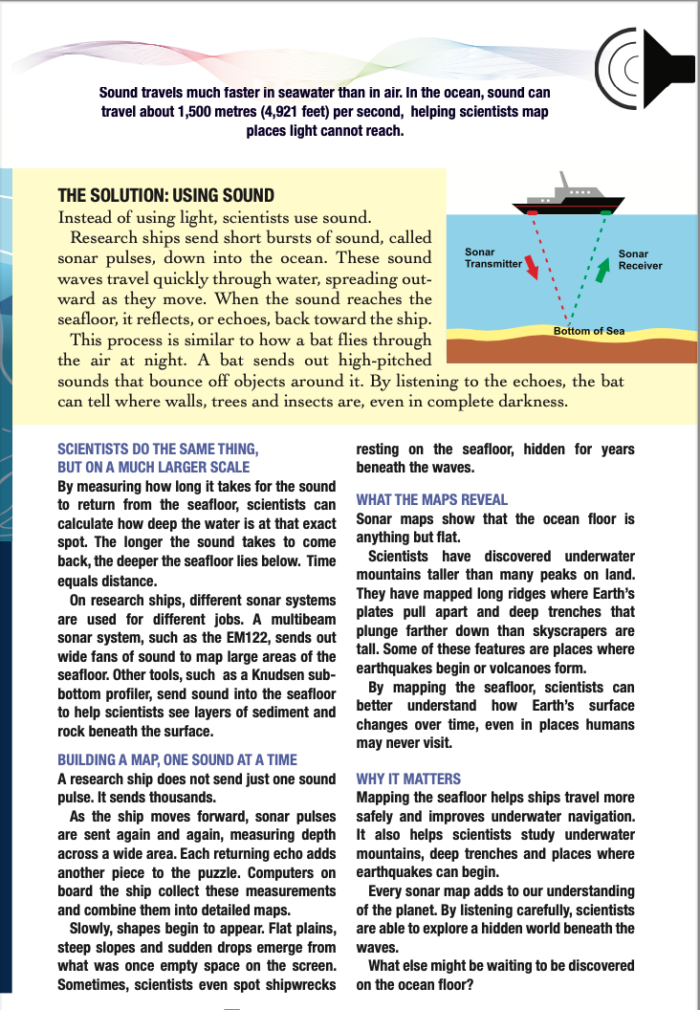
Instead of using light, scientists use sound. Research ships send short bursts of sound, called sonar pulses, down into the ocean. These sound waves travel quickly through water, spreading out- ward as they move. When the sound reaches the seafloor, it reflects, or echoes, back toward the ship. This process is similar to how a bat flies through the air at night. A bat sends out high-pitched sounds that bounce off objects around it. By listening to the echoes, the bat can tell where walls, trees and insects are, even in complete darkness.
.
SCIENTISTS DO THE SAME THING, BUT ON A MUCH LARGER SCALE
By measuring how long it takes for the sound to return from the seafloor, scientists can calculate how deep the water is at that exact spot. The longer the sound takes to come back, the deeper the seafloor lies below. Time equals distance. On research ships, different sonar systems are used for different jobs. A multibeam sonar system, such as the EM122, sends out wide fans of sound to map large areas of the seafloor. Other tools, such as a Knudsen sub- bottom profiler, send sound into the seafloor to help scientists see layers of sediment and rock beneath the surface.
.
BUILDING A MAP, ONE SOUND AT A TIME
A research ship does not send just one sound pulse. It sends thousands. As the ship moves forward, sonar pulses are sent again and again, measuring depth across a wide area. Each returning echo adds another piece to the puzzle. Computers on board the ship collect these measurements and combine them into detailed maps. Slowly, shapes begin to appear. Flat plains, steep slopes and sudden drops emerge from what was once empty space on the screen. Sometimes, scientists even spot shipwrecks resting on the seafloor, hidden for years beneath the waves.
.
WHAT THE MAPS REVEAL
Sonar maps show that the ocean floor is anything but flat. Scientists have discovered underwater mountains taller than many peaks on land. They have mapped long ridges where Earth’s plates pull apart and deep trenches that plunge farther down than skyscrapers are tall. Some of these features are places where earthquakes begin or volcanoes form. By mapping the seafloor, scientists can better understand how Earth’s surface changes over time, even in places humans may never visit.
.
WHY IT MATTERS
Mapping the seafloor helps ships travel more safely and improves underwater navigation. It also helps scientists study underwater mountains, deep trenches and places where earthquakes can begin. Every sonar map adds to our understanding of the planet. By listening carefully, scientists are able to explore a hidden world beneath the waves. What else might be waiting to be discovered on the ocean floor?